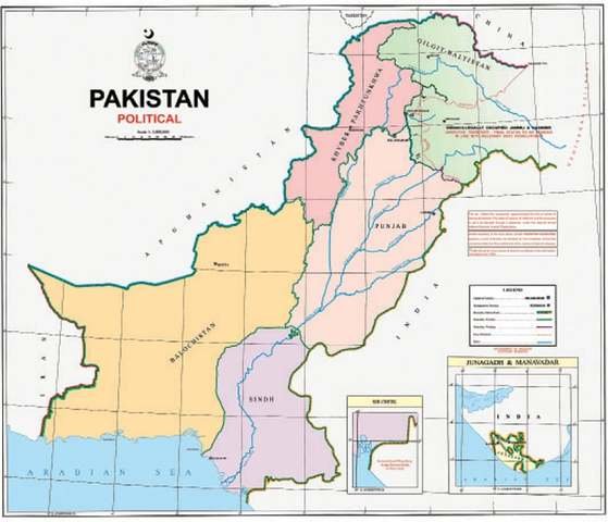
Imran Khan Unveils New Pakistani Map with Indian Occupied Kashmir in Pakistan's Territory.
Prime Minister Pakistan, Imran Khan on Tuesday approves a new Pakistani Map. As per the new Pakistani map, Indian Occupied Kashmir is a part of Pakistan

"Kashmir will become part of Pakistan and this map is the first step toward it,"
Prime Minister Pakistan, Imran Khan on Tuesday approves a new Pakistani Map. As per the new Pakistani map, Indian Occupied Kashmir is a part of Pakistan. Imran Khan while briefing in a meeting said:
“It is a historic occasion. The political map reflects our national aspiration and supports our principled stance on Kashmir dispute,”
The map comes out one day before the completion of one year of the occasion of annexation of occupied Kashmir.
India had annexed the held territory on Aug 5 last year by revoking articles 370 and 35A of its constitution, which had provided special status to occupied Kashmir and rights and privileges to Kashmiris.
Also Read: https://nationbytes.com/beirut-port-explosion-claims-50-lives-leaving-thousands-injured
Furthermore, India also launched its new map in October last year. Noticeably, India had through its map claimed the entire disputed area, including Azad Kashmir and Gilgit-Baltistan, as part of its territory. But, China, Pakistan, and Nepal rejected that map.
PM Khan hailed the new Pakistani map as the “first step” towards resolution of the nearly 73-year-old dispute. He, however, emphasized that Pakistan believed in a political solution to the dispute. He said the map rejected India’s illegal action of annexing held Kashmir.
“It is the first time that the aspirations of Pakistani nation and our stated position on the dispute are being given with such clarity,” Said PM Khan.
The map was launched after the approval by the federal cabinet. Foreign Minister Shah Mehmood Qureshi had earlier in the day briefed the legislators from opposition parties on the map during a meeting at the Foreign Office.


